Cycling track around the gypsum karst formation of Gaibola
Updated on 13 May 2026 From Federico Farinelli
Updated on 13 May 2026 From Federico Farinelli
The Gaibola gypsum karst Cycle Route winds through one of the most evocative and unusual landscapes of the lower hills around Bologna, where gypsum rock has shaped karst landscapes, natural cavities and scenes of great charm. It is a relatively short circular cycle route, but one that should not be underestimated due to its climbs and unpaved sections; it is ideal for exploring the Gessi Bolognesi and Calanchi dell’Abbadessa Regional Park, cycling through nature, geology and hilly landscapes.
Length: 21 km (including a detour to the WWF Molino Grande River Oasis)
Elevation gain: 200 m
Difficulty: moderate (includes a short uphill section on a dirt track, though not particularly challenging)
Duration: a few hours/half a day
Type: loop route on mixed terrain (tarmac, gravel, single track)
Protected area: Gessi Bolognesi and Calanchi dell’Abbadessa Regional Park
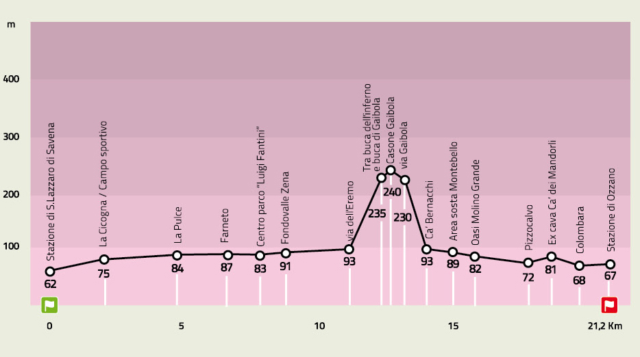
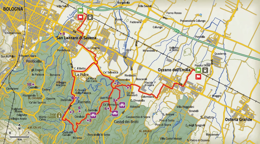
The route can be started from either San Lazzaro di Savena railway station or Ozzano dell’Emilia railway station, making it easily accessible even for those arriving by train.
After an initial urban stretch along recently built cycle paths, you reach the village of Pizzocalvo, recognisable by the small church perched on a green hilltop overlooking the surrounding hills. From here, you gradually enter the Parco dei Gessi Bolognesi, an area characterised by the presence of gypsum, a rare rock that has given rise to a karst landscape rich in natural cavities, sinkholes and swallow-hole caves.
At Via Tomasella, the route offers two options:
The first leads eastwards, crossing the WWF Molino Grande River Oasis along the Idice stream. This section runs through a damp, shaded environment, amongst poplars, willows and black alders, with undergrowth rich in dogwood, elder, field maple and dogwood. This route has gentle gradients but features technical and occasionally muddy sections: for this reason, it is recommended primarily for mountain bikes.
The main alternative continues south along Via Montebello and, after about 750 metres, climbs to the right towards Gaibola on a steep road that soon becomes a dirt track. This is the most challenging section of the route, but also one of the most picturesque: the path crosses stretches of bare gypsum rock and leads into the heart of the karst landscape of the Gessi Bolognesi, amidst large sinkholes and woods that in spring are filled with blooms of snowdrops, bluebells and dog’s-tooth violets.
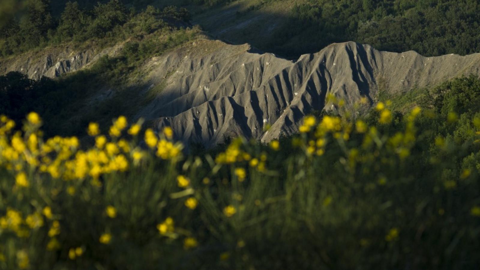
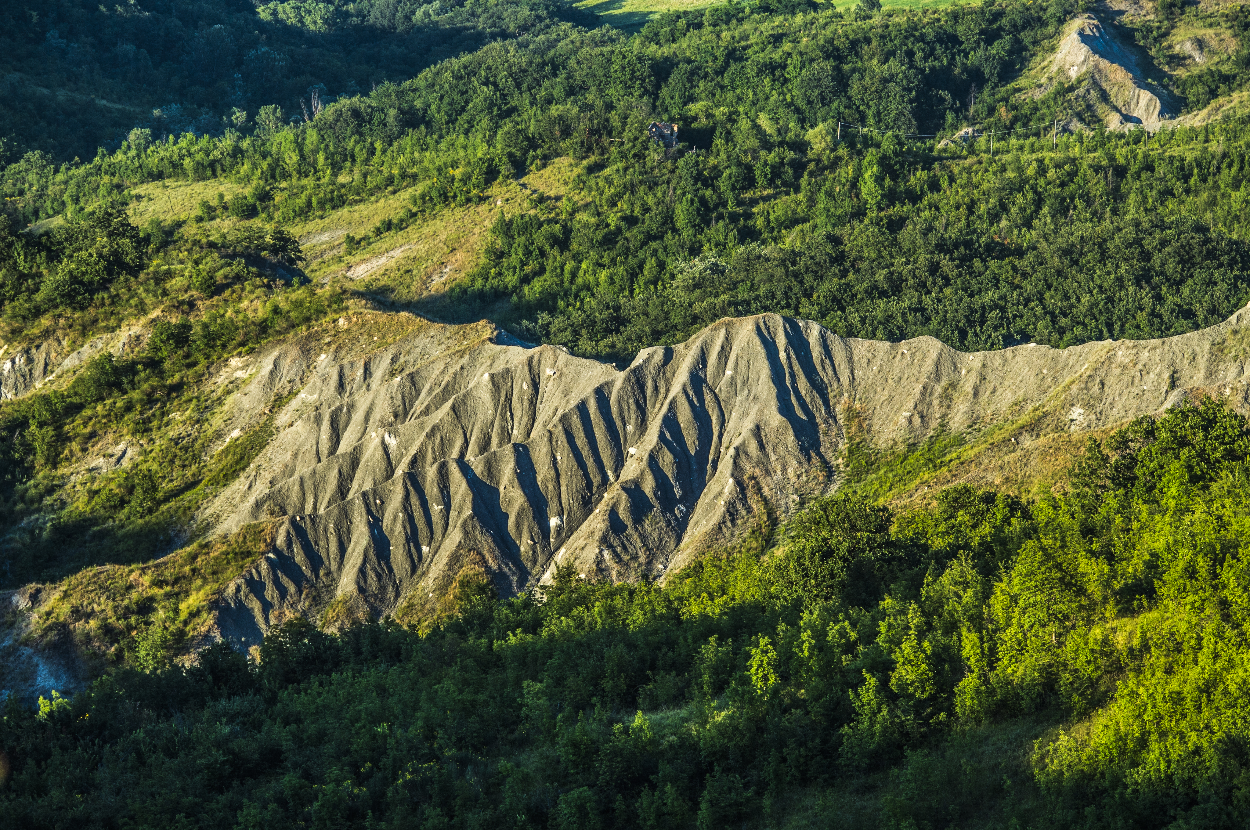
Once past Gaibola, the route runs alongside the large sinkholes of Buche di Gaibola, Ronzano and d'Inferno: sites representative of the Bolognese karst landscape and of particular interest to geology and caving enthusiasts.
Just beyond Coralupi, you reach Via dell’Eremo and descend towards the Zena valley floor, where you’ll find the “Luigi Fantini” Park Centre, dedicated to the founder of the Bolognese Speleological Group, and the nearby Grotta del Farneto. Discovered in 1871, the cave is one of the area’s most important sites due to its historical, archaeological, educational and tourist value.
The route finally reaches the village of La Cicogna: from here, you can return to San Lazzaro di Savena by following the cycle path or continue along Via Palazzetti to the railway station at Ozzano dell’Emilia.
When to go: Spring and autumn are the best times to cycle along the Gessi di Gaibola cycle route: temperatures are pleasant and the landscape offers blossoms, colours and particularly picturesque views.
Hydration: Take a full water bottle with you, especially on hot days. The route passes through natural and hilly terrain where refreshment points are not always available.
Route: The route is short but varied: it alternates between cycle paths, climbs, dirt tracks and stretches surrounded by nature. It’s best to tackle it with at least some cycling experience.
Equipment: Mountain bikes and gravel bikes are the most suitable options. A small puncture repair kit is always useful, particularly if you choose the WWF Molino Grande Oasis route.
Navigation: Before setting off, you can download the GPX track for GPS devices or dedicated apps. A KMZ file is also available to view the route and points of interest on Google Earth.
Useful app: The route can also be viewed via the Emilia-Romagna Region’s Maps4You app, in the ‘Culture and Tourism’ > ‘Alta Via and Park Cycle Routes’ section.
Accessibility: The circular route can be reached from both San Lazzaro di Savena railway station and Ozzano dell’Emilia railway station.
“L. Fantini” Park Visitor Centre Via Jussi 171
Loc. Farneto – San Lazzaro di Savena (BO)
Tel. (+39) 051 6254811
info.parcogessi@enteparchi.bo.it
www.enteparchi.bo.it


Discover Bologna Welcome's newsletters and choose the one that suits you best: events, tips, tours delivered directly to your inbox
Subscribe


